Showing posts with label LBS. Show all posts

Friday, 23 October 2020

Positioning Techniques for 5G NR in 3GPP Release-16

I realised that I have not looked at Positioning techniques a lot in our blogs so this one should be a good summary of the latest positioning techniques in 5G.

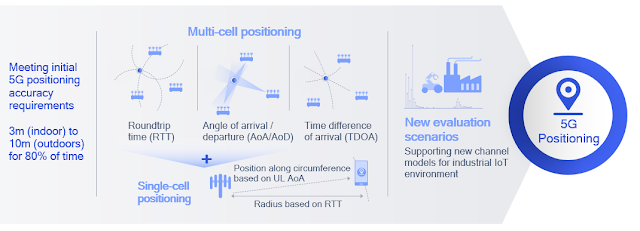
Qualcomm has a nice short summary hereRelease 16 supports multi-/single-cell and device-based positioning, defining a new positioning reference signal (PRS) used by various 5G positioning techniques such as roundtrip time (RTT), angle of arrival/departure (AoA/AoD), and time difference of arrival (TDOA). Roundtrip time (RTT) based positioning removes the requirement of tight network timing synchronization across nodes (as needed in legacy techniques such as TDOA) and offers additional flexibility in network deployment and maintenance. These techniques are designed to meet initial 5G requirements of 3 and 10 meters for indoor and outdoor use cases, respectively. In Release 17, precise indoor positioning functionality will bring sub-meter accuracy for industrial IoT use cases.

I wrote about the 5G Americas white paper titled, "The 5G Evolution: 3GPP Releases 16-17" highlighting new features in 5G that will define the next phase of 5G network deployments across the globe. The following is from that whitepaper:

Release-15 NR provides support for RAT-independent positioning techniques and Observed Time Difference Of Arrival (OTDOA) on LTE carriers. Release 16 extends NR to provide native positioning support by introducing RAT-dependent positioning schemes. These support regulatory and commercial use cases with more stringent requirements on latency and accuracy of positioning.25 NR enhanced capabilities provide valuable, enhanced location capabilities. Location accuracy and latency of positioning schemes improve by using wide signal bandwidth in FR1 and FR2. Furthermore, new schemes based on angular/spatial domain are developed to mitigate synchronization errors by exploiting massive antenna systems.

The positioning requirements for regulatory (e.g. E911) and commercial applications are described in 3GPP TR 38.855. For regulatory use cases, the following are the minimum performance requirements:

  • Horizontal positioning accuracy better than 50 meters for 80% of the UEs.
  • Vertical positioning accuracy better than 5 meters for 80% of the UEs.
  • End-to-end latency less than 30 seconds.

For commercial use cases, for which the positioning requirements are more stringent, the following are the starting-point performance targets

  • Horizontal positioning accuracy better than 3 meters (indoors) and 10 meters (outdoors) for 80% of the UEs.
  • Vertical positioning accuracy better than 3 meters (indoors and outdoors) for 80% of the UEs.
  • End-to-end latency less than 1 second.

Figure 3.11 above shows the RAT-dependent NR positioning schemes being considered for standardization in Release 16:

  • Downlink time difference of arrival (DL-TDOA): A new reference signal known as the positioning reference signal (PRS) is introduced in Release 16 for the UE to perform downlink reference signal time difference (DL RSTD) measurements for each base station’s PRSs. These measurements are reported to the location server.
  • Uplink time difference of arrival (UL-TDOA): The Release-16 sounding reference signal (SRS) is enhanced to allow each base station to measure the uplink relative time of arrival (UL-RTOA) and report the measurements to the location server.
  • Downlink angle-of-departure (DL-AoD): The UE measures the downlink reference signal receive power (DL RSRP) per beam/gNB. Measurement reports are used to determine the AoD based on UE beam location for each gNB. The location server then uses the AoDs to estimate the UE position.
  • Uplink angle-of-arrival (UL-AOA): The gNB measures the angle-of-arrival based on the beam the UE is located in. Measurement reports are sent to the location server.
  • Multi-cell round trip time (RTT): The gNB and UE perform Rx-Tx time difference measurement for the signal of each cell. The measurement reports from the UE and gNBs are sent to the location server to determine the round trip time of each cell and derive the UE position.
  • Enhanced cell ID (E-CID). This is based on RRM measurements (e.g. DL RSRP) of each gNB at the UE. The measurement reports are sent to the location server.

UE-based measurement reports for positioning:

  • Downlink reference signal reference power (DL RSRP) per beam/gNB
  • Downlink reference signal time difference (DL RSTD)
  • UE RX-TX time difference

gNB-based measurement reports for positioning:

  • Uplink angle-of-arrival (UL-AoA)
  • Uplink reference-signal receive power (UL-RSRP)
  • UL relative time of arrival (UL-RTOA)
  • gNB RX-TX time difference

NR adopts a solution similar to that of LTE LPPa for Broadcast Assistance Data Delivery, which provides support for A-GNSS, RTK and OTDOA positioning methods. PPP-PTK positioning will extend LPP A-GNSS assistance data message based on compact “SSR messages” from QZSS interface specifications. UE-based RAT-dependent DL-only positioning techniques are supported, where the positioning estimation will be done at the UE-based on assistance data provided by the location server.


Rohde&Schwarz have a 5G overview presentation here. This picture from that presentation is a good summary of the 3GPP Release-16 5G NR positioning techniques. This nice short video on "Release 16 Location Based Services Requirements" complements it very well. 


Related Posts:

Tuesday, 9 September 2014

LTE Device-to-device (D2D) Use Cases

Device-to-device is a popular topic. I wrote a post, back in March on LTE-Radar (another name) which has already had 10K+ views. Another post in Jan, last year has had over 13K views. In the LTE World Summit, Thomas Henze from Deutsche Telekom AG presented some use cases of 'proximity services via LTE device broadcast'


While there are some interesting use cases in his presentation (embedded below), I am not sure that they will necessarily achieve success overnight. While it would be great to have a standardised solution for applications that rely on proximity services, the apps have already come up with their own solutions in the meantime.

Image iTunes

The dating app Tinder, for example, finds a date near where you are. It relies on GPS and I agree that some people would say that GPS consumes more power but its already available today.


Another example is "Nearby Friends" from Facebook that allows to find your friends if they are nearby, perfect for a day when you have nothing better to do.

With an App, I can be sure that my location is being shared only for one App. With a standardised solution, all my Apps have info about location that I may not necessarily want. There are pros and cons, not sure which will win here.

Anyway, the complete presentation is embedded below:


For anyone interested in going a bit more in detail about D2D, please check this excellent article by Dr. Alastair Bryon, titled "Opportunities and threats from LTE Device-to-Device (D2D) communication"

Do let me know what you think about the use cases.

Tuesday, 4 March 2014

LTE Radar - LTE proximity services

Last year, DT gave an interesting presentation on what they termed as 'LTE Radar'. Here is the video to explain the motivation:


The picture below summarises how this will work:


It is interesting to note that these problems are already being solved using Apps and other technologies. Once the 3GPP standard is finalised, it would be a challenge to get this to mass adoption. An example would be Bluetooth based Beacons that I blogged about earlier here. Nevertheless, it would be interesting to see how compelling the use cases would be once this is standardised. The complete DT presentation is embedded below:


Monday, 28 March 2011

Friday, 8 October 2010

Ultrawideband (UWB) based In-building Location Systems

Continuing on yesterdays theme of Location determination. I have heard in couple of presentations that in future based on multiple RF radios that we will carry, we could be uniquely identified on the planet even though there may not be a single device identifying us uniquely.

A similar project as above but for computers is the Panopticlick project which can be found here.


Thursday, 7 October 2010

Locating Wireless Devices Where GPS May Not Be Available

Some of you may have read my earlier posts on stealing spectrum via Femtocells and using Femtocells abroad illegally. This presentation tries to answer one such problem on how do you find the location where GPS cannot be used. This could also be used in case of Cognitive Radios. See my old blog entry here.

Thursday, 30 September 2010

RF Pattern Matching adopted in 3GPP Release-10

RF Pattern Matching is now a recognized unique location method in standards that provides carriers and OEMs with the ability to offer high accuracy location-based services that traditionally haven’t been available with low-accuracy Cell-ID based technologies. RF Pattern Matching will be incorporated into Release 10 of the 3G UMTS specifications, expected to become final in late 2010 or early 2011. This will also set the stage for opportunities to incorporate RF Pattern Matching into LTE and other future air interfaces.


“The decision to incorporate RF Pattern Matching into the 3G UMTS specifications is needed for all service providers wanting to provide the highest-SLA option for LBS as it gives them more credible options for public safety and commercial applications,” said Manlio Allegra, president and chief executive officer at Polaris Wireless. “This level of LBS accuracy will create an improved user experience for wireless customers, which ultimately generates additional revenue streams for carriers and other enterprises offering LBS applications.”


Polaris WLS™ is a patent-protected implementation of RF Pattern Matching, which provides the best network-based location performance in urban and indoor settings and is a perfect complement to A-GPS, enabling a best-in-class hybrid solution. Polaris’ WLS™ works without the RF Pattern Matching definition in standards, but standardization through 3GPP allows for future performance enhancements and provides flexibility for the solution and carrier implementations. Polaris’s current WLS products will continue to operate within existing standards.


By being included in the 3G UMTS standard, Polaris’ location technology has received further validation as one of the most accurate in the world. Polaris will now be considered a preferred provider to Tier 1 carriers and infrastructure vendors who want to add a high accuracy location solution to their technology mix that meets the new 3GPP standard.


The FCC is currently considering new E911 Phase II regulations that would improve indoor location capabilities for first responders. Using RF Pattern Matching, Polaris’ WLS™ software solution enables carriers and OEMs to be prepared to meet these new FCC requirements with little or no investment in new infrastructure or hardware.

RF Pattern Matching Discussion document presented in 3GPP is embedded below:


Wednesday, 9 December 2009

Location Based Systems/Services Presentations


Interesting presentations from Cambridge Wireless on LBS:

"How do we Make Location a Desirable User Experience?"

Click on the titles below to view the provocateurs' presentations and the notes from the three group discussions -

Introduction from Colin Smithers of Plextek

Group 1: Technology - Presentation by Adrian Swinburne of Quintaxiom + Faciliator's Notes

Group 2: Context - Presentation by Kurt Lyall of Xgenta + Faciliator's Notes

Group 3: Privacy - Facilitator's Notes


Thursday, 25 June 2009

SatNav need an integrated solution

Satellite navigation has evolved significantly in the past decade and the technology is now used in almost every walk of the life. Every body uses the satellite navigation to reach to certain destination.

But imagine that you have a navigation tool or gadget which acts as your own personal travel guide. It has satellite navigation, so when you get into your car it can direct you to where you want to go. It can choose the most carbon-efficient route and make sure you avoid crowded town centres, traffic jams and road works. It can let you know where the next petrol station is, and whether there is an Italian restaurant near your hotel. Before you arrive you will know which of the town car parks have spaces left. And when you've finally parked the car, take your guide with you and it will direct you, on foot, to your final destination.

For anyone who has found themselves stuck in a traffic jam, or has been unable to find a car park in a busy town centre, or has got lost on foot, it sounds too good to be true. Yet the technology to make it happen is already here. So why aren't we all carrying such a device in our pockets?

The question which then arises is that why the universal travel widget isn't at hand. One of the reasons for that is that several different worlds have to collide and co-operate. First of all there is a massive competition together with a huge confusion regarding the platforms in which such device can be built on. To start with we have got proprietary platforms like TomTom and Garmin, and then we've got the at least five major mobile phone operating systems.

The obvious competition between these different platforms has instigated some suspicion but apart from this the mobile companies also have yet to ¬recognize the potential of phones as navigation devices.

You can argue that many mobile phones are already GPS-enabled but in my opinion this doesn't necessary make them effective at navigation. For instance try using your blackberry as a navigation device and you’ll find that battery has quickly drained out. The mobile phone world is slowly coming to terms with the needs of navigation on mobiles, such as better ¬battery life and bigger screens. Infact GPS alone doesn't offer the precision needed to navigate pedestrians, and so to be useful needs to be combined with another positioning service such as Wi-Fi. This has been done with the iPhone, for example.

The accuracy and granularity of data used in satellite navigation systems is very critical and has to be improving all the time. The real problem lies in integration where the data needed to provide a coherent information service to a navigation device is held by different organisations in a number of different places. While there are companies that are providing some location-based information such as information about ATMs, speed cameras, train times or tourist sites but there is no company in my knowledge that offers everything.

Combining all the information and hence provided through a single device at a one point of time that information isn't going to be easy. The challenges which lies in this are not solely technical for example there's a data aggregation problem to bring it altogether, including highway changes, updates from local authorities and then there's a physical problem in gathering all that up.
Even if the above issues are solved there is still a major part of the problem which is revenue. How one would make money out of integrated Satnav device? There's a difference between what can be done technically and a viable ¬product that can be sold. How do you turn that into something that fits in a business model?"

Organisations that have valuable data rarely want to give it away for free, licences to reuse companies or government’s mapping data commercially are expensive. Similarly, there is no incentive for the Highways Agency or local authorities, for example, to share information about traffic conditions. Even the government website Transport Direct, which provides free up-to-date transport information, has restrictions on the integration of its content with other services.

So now you may realize that how trying to highlight the potential of the problem. It’s a mammoth task to bring all the above information together into one place as everyone wants their pound of flesh because everyone has developed their own data infrastructure and it's just very difficult to get them to agree.

I certainly hold the opinion that inspite of all these hiccups the demand for an all-in-one travel service almost certainly exists. People simply really want a so called integration or integrated device which can work across different ¬locations i.e. home, work, on the move etc.

It’s evident from the above facts that the emergence of a ¬genuinely integrated solution will depend on a government initiative to force public sector organisations such as Highways Agencies, Transport for London and local authorities to collaborate, or on a private sector organisation taking a ¬commanding lead in terms of developing location technologies.
Google is one such company which is creeping up with a whole series of ¬initiatives that are steadily putting the pieces in place. Best example for this is Google Maps which are now readily available on all mobile platforms and is integrated with traffic data from the Highways Agency. Not only this, the Google Maps application interface (API) allows third parties to build their own applications as well.

Google, no doubt is leading with an example in terms of it’s initiatives towards serving the customers in best possible way. Google certainly knows what the customers want which I believe a mini innovation in these current economic climate.

Location has always been such an absolutely fundamental framework for our lives, and we inevitably must embrace tools that allow us to manage that. I envisage a society in 20 years' time revolutionised by the ability to know all the location based information.

Wednesday, 6 May 2009

Is 'Toilet Locator' the next killer App?

I blogged earlier that Westminster city council in London using 'SatLav' service to guide you to nearest loo. Now according to news item The Daily Telegraph, UK, The trials and tribulations of searching for the nearest public toilet have been eliminated in Japan – with the launch of mobile phone software guiding users to the nearest lavatories.

The Check A Toilet programme, created by the software company Access Co, enables mobile phone users to search for maps highlighting the nearest public lavatory to their location.

From train stations and beaches to department stores and parks, the software lists thousands of maps highlighting the location of public lavatories, including details of their facilities such as baby changing areas, according to reports in Mainichi Daily News.

Users of the mobile lavatory locator are able to upload the free software from the Check A Toilet website whose lavatory location database stretches across Japan, from Tokyo to the northern city of Sapporo.

The software reflects the continually growing importance of mobile phones in every day life in Japan, home to the largest mobile phone market in the world.

Buying groceries, paying for train tickets and reserving cinema tickets are among a string of increasingly popular uses for mobile phones, 50 million of which are sold in Japan every year.

The Check a Toilet Widget, developed in cooperation with NPO Check, who created the toilet map, is a free download available for phones running Windows Mobile or Symbian S60. Entering your location in the search window brings up a map with the local lavatories indexed by number, with successive clicks revealing whether they are equipped for baby-changing or are barrier-free.


Finding toilets is a very important activity as I am sure everyone must have had a bad day when they need to go to one but cant seem to find one. There are many different ways in which local governments and application developers worldwide are trying to solve this important proble ;)

In Beijing (China), there are electronic maps at all public places with flashing lights showing public toilets. Beijing holds the world record for most public toilets in a city. Australian government has created a National Public Toilet map that can also be easily accessed via mobiles. In New York, USA, Diaroogle is serving as a premier toilet search engine. Have2P is a 'Restroom Locator and Everyday Lifesaver' app on iPhone.

Any more you know of? Feel free to add in the comments.

Friday, 9 January 2009

LBS to find parking space

Drivers in Westminster in London can now solve their parking problems by sending a text message.

Westminster City Council, which pioneered a satellite navigation system to help people find nearby public toilets, has adapted its technology to help visitors park in the area.

Drivers who text CARPARK to 80097 will get a text back within seconds giving them details of their nearest car parks, based on their current location.

The service uses satellites to locate the phone when the message is sent allowing it to return information accurate to less than one mile.

The technology directs users to the nearest two of the council's 14 car parks across Westminster.

Locals can also text to receive an instant message back with details of the location and phone number of their nearest leisure centre, swimming pool, library, youth club or children's centre.

The authority hopes the system will eventually be used nationwide.

The service costs 25p (plus standard network charge) per text sent to the 80097 number.

There seems to be some confusion about the technology being used but my assumption is that it is Location Based Service. This service was earlier also referred to as 'SatLav' (SatNav + Lavoratory: because it was initially used to locate nearest toilets :)

Earlier, Robert Thurner, Commercial Director of Incentivated, which created the technology to pin-point users and their nearest toilet by matching postcodes, said:

"By employing the latest mobile technology, councils like Westminster Council are helping to make residents' lives easier. Whether they want to pay the congestion charge via their mobile or use location based services to find their nearest recycling centres or licensed minicabs, mobile can offer an immediate solution, at any time and anywhere. We applaud Westminster Council for adding text-public conveniences to their list of services and look forward to working with them in the future."

In future it could be used for a lot more different purposes.

I am not totally convinced if this is a great idea, expecially for parking:
  • In UK, users are not allowed to use mobile while driving so how do they send the text message?
  • If you park temporarily on the road to send this text message then you can get parking fine or you may just block other users
  • You may send this text message while driving, in which case by the time you receive the response you have already travelled some distance.
  • Generally SMS responses are quick but in congested situation they can take time.
  • 25 pence + 10 pence network charge seems a lot to me if people are going to use this service regularly and its rolled out nationwide.
  • A simpler alternative it to get a SatNav (available from 50 pounds) and they have Parking as points of interest.
  • Google maps for mobile already uses LBS. Its just matter of time before they add this service and you can avail it free (or maybe pay some data charges if you are not on flat tariff).
Anyone seen this or similar services in action? Please give your opinion.

Sunday, 16 November 2008

Mobile advertising will grow

As the technology has evolved over the last decade so does various mobile applications and services related to it. In today’s competitive and saturated market operators and vendors are spending significant amount of time in drafting new strategies which will result in new revenue generation.

It is all about making the consumer interested and getting into the feeling of the general public in terms of what they would like and what would interest them. Mobile advertising is one such step in that area.

In the last year alone mobile advertising had emerged and there is a buzz out there related to it. I have noticed that people including myself take more notice of a mobile ad than advertising on TV or on a PC screen. And with a billion new phones being bought every year, the potential market is huge. Does this really mean that people out there really believe that it's going to be worth billions in just another two to three years?

There is no denying from the fact that mobile phones offer advertisers many different ways to reach an audience. With more and more people accessing internet from their mobile there is a potential area for growth. Placing ads at the start of a video or adding them to the results of a mobile search are less intrusive forms of promotion. I think we'll see people responding well to this kind of ad.For one thing the credit crunch will force advertisers to reduce traditional outlets like print and TV, and push them to explore cheaper and more targeted avenues, such as mobile devices.
So eventually, revenue from mobile advertising might rival that on other channels. But until then the industry will have to knock a few zeros off its forecasts.
You mist have noticed receiving various SMS from your operator sending you a message related to some product or event. SMS advertising for consumer goods, such as food and fashion is rising significantly specially in Europe.

Recent study by comScore suggested that more customers were getting ads for consumer goods such as food, fashion, restaurants, travel and financial services. In the three months ended August 2008, the number of offers received for non-mobile consumer goods rose 15 percent, compared to last year.

Food is the fastest-growing category of SMS advertising since August 2007, at a rate of 53 percent, followed by clothing-fashion at 38 percent and restaurants at 37 percent.
Mobile advertising is relatively new in the market and just like any other new thing it will take some time to settle down. However there are some articles floating around which suggest that mobile advertising is overhyped. Although these suggestions are based on some fact and data collected by the reputed analysts, I still do believe that mobile advertising will pick up especially after the latest credit crunch. In my view every time we see a launch of a new product or new technologies there is an excitement around it and in this process sometimes it gets overhyped. Same might be true with mobile advertising as well.

But like the Internet revolution before it, mobile needs to emerge from the technology foothills and develop media experiences and advertising solutions that delight and satisfy real consumers' needs and wants.